 Company:
This southeastern U.S. company provides general contracting, construction management, and design/build services for larger commercial, industrial, and institutional projects.
Challenge:
With a deadline of just three weeks looming, new material-conveying systems had to be installed into existing structures at nine far-flung sites. The modifications would expand capabilities to new structures while avoiding interferences with old ones. The scale of the entire project was huge due to the large sizes of the onsite locations, the distance between locations, and the time constraints.
Laser Design was quick to react to all our requests, dealt with logistical problems of having 3 weeks to scan in 7 states. Laser Design was very responsive to all our issues. I wouldn’t hesitate to use Laser Design again for projects that require 3D scanning solutions.”
Solution:
The company contracted with Laser Design Services Corp. to perform long-range scanning on the existing structures and conveyor systems. To assure that interferences with new installs would not occur, surrounding areas were included in the scan perimeter as well as inside buildings that contained current conveyor systems. The detailed geographic information of the extended area was critical to the success of the large-scale system installs and the design of new adjacent structures. Normally, surveying teams would perform this type of operation. However, with the tight deadline, using time-consuming surveying methods would not be feasible. The Laser Design scanning team brought their advanced tools into the surveying realm, where long-range laser scanning replaced the slow, labor-intensive traditional surveying methods of measurement.
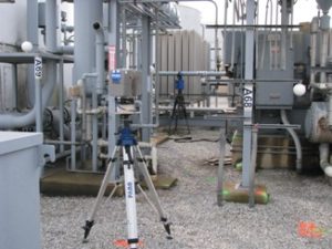
Laser Design engineers used the FARO Focus 3D to perform the long-range scans. Long-range scanning is a ground-based technique for collecting high-density large-scale 3D geospatial data of complex environments, such as entire buildings, factories, rooms, landscapes, and other big structures and locations, both inside and out. For each of the nine scanning locations, the experienced Laser Design engineers chose the optimal four places to position the Focus to completely gather the needed 3D data of that location’s features for the 3D model. The process of setting up and performing the onsite scans took around one-half day at each location. Surveyors would have required two days onsite to produce a 2D footprint with general dimensions of features which would not come close to representing the actual existing structures.
The highly accurate 3D scan data generated with 3D scanning can be used to view the as-built region in a virtual world. The contracting company quickly had the detailed geospatial information they needed to design their builds. The point cloud data was surfaced to generate a CAD model for comparison or reconstruction of each site. The size of the specimen being scanned is not limited to the directional travel of a machine or the reach of an arm. The scanner measures 360º by 320º to a range of 120 meters in any one setup and maintains an accuracy of ±2mm to a distance of 25 meters away.
Scans can be taken anywhere, at virtually any time including broad daylight, the dark of night, indoors, and outdoors. The raw output of long-range scanning is “point-cloud” data, which Laser Design can use as reference to create a fully parametric file in almost any native format. Scan data can be rendered in color, where each measured XYZ coordinate is assigned an RGB color value.
Results:
Each large onsite scan took about one-half to one day to perform, some sites taking as little as three hours. The scan data was processed and refined in Geomagic, eliminating the extraneous data from the surroundings and focusing on the areas in question. AutoCAD files were then delivered to the company. When a project of this magnitude is undertaken, normal turnaround time from scanning to deliverable files is only 1 or 2 weeks, a time savings of 60% in data gathering and processing time of traditional methods. However, due to the rush nature of this extensive project, turnaround for some sites was as little as 3-4 days, saving up to 75% in data gathering and processing time.
The astonishing speed capabilities of the long-range scanner along with the expertise of the Laser Design team solved the time-crunch problem for the contracting company. If conventional surveying methods had been used, the measurement process could have taken weeks on each site. The resulting models would have been in 2D with much less structural information and detail. Also, the measurements would not have been as accurate because manual methods incur much more human error. 3D long-range laser scanning provided a complete 3D map of all the structures and conditions in the area of interest, enabling engineers to update systems and construct additions without the risk of interference with existing structures.
“We did the right thing to hire Laser Design,” stated the engineer in charge of the large-scale project. “Laser Design was quick to react to all our requests, dealt with logistical problems of having 3 weeks to scan in 7 states. Laser Design was very responsive to all our issues. I wouldn’t hesitate to use Laser Design again for projects that require 3D scanning solutions.”
